

ECHOES IN THE LANDSCAPE OF AN EARLY MEDIEVAL MANOR IN WESTMORLAND
Whilst researching the history of the impressive Tudor manor house at Gaythorne Hall, an ancient land charter has revealed clues about life on the land. Information that has been hidden since before the 13th century. By matching the features in this remote valley with a land charter from 1239, a rare insight has been gained into how people strove to farm and prosper in this secluded valley. Many of its secrets are being discovered after hundreds of years.
The boundaries of Gaythorne Hall
Before the turn of the 12th century, Westmorland was part of Scotland. In 1239, within three generations of Westmorland being annexed into England, Ivo de Veteripont gave Gaythorne Hall to the Church “for the safety of my soul”. The boundaries of the land were described in words in a charter and not on a map as would be done in modern times. The ancient documents referred to many features and places, some of which have disappeared from history, but some remain to provide clues about life in those times. The estate boundary was described as passing from “the older mill pond….to the ghil next the ploughed land….as far as the Great Dyke…up to the great stone and then to the end of the four stones..” Other place names have disappeared from modern maps, but the questions remain, where is the ancient mill pond? What is the Great Dyke? Do the ancient stones still survive?
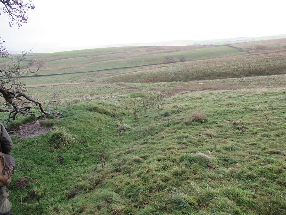
Finding the Great Dyke
The key to this detective work started with finding the Great Dyke and understanding how it fitted into the landscape. Banks and ditches, or dykes, have long been used to demark the boundaries of land since at least the Saxon period and in some areas since prehistoric times. Our recording of the landscape has now shown that this dyke is an impressive boundary bank and ditch, still over 1.5 metres high after almost 1,000 years since the 1239 charter. The 1239 estate boundary passed over it, not along it, so it was already ancient by that time and tells us that it was a substantial boundary from an earlier historic period. Could this be an echo from an earlier Saxon estate from the time when Westmorland was part of ancient Northumbria? When our research has recorded all the dykes, or ‘cams’ as the local farmers call them, perhaps its origins will become clearer.
Discovering the ancient stones & old mill pond
But what of the ancient stones and the old mill pond? References to some of the stones were found on old maps but have sadly disappeared from the landscape. But the ‘ploughed land’ has been found with its ancient ‘rig and furrow’ rolling surface next to a ‘gill’, or narrow valley with a stream. With those clues in place, and the location of the Great Dyke confirmed, the next step in our detective work will be to follow the edge of the ploughed land until we find the site of the old mill pond. But what will we be looking for? All mills had ‘leats’ or water channels to redirect water from a stream to point where a small horizontal wheel would have driven a grinding stone under a simple timber or stone structure; there would then be the tell-tale sign of another water channel leading back to the stream.
The hunt is on!
Learn more about Lewis Conservation’s projects and don’t forget to follow us on Facebook to be notified of future historical building blogs.